Highwood night lights from space
Night Light of Highwood (Illinois) from space (United States) Src. Average luminocity for 10x10km area is 49.1985% and for 50x50km: 48.398%.
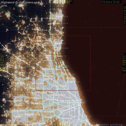
Analysis of Highwood night lights 2016
Square area 10x10 km:
 6.21%
6.21%90-99
4.7%80-89
4.7%70-79
7.27%60-69
16.52%50-59
17.73%40-49
7.42%30-39
1.21%20-29
10.3%10-19
14.09%0-9
9.85%Square area 50x50 km:
14.38%90-99
12.3%80-89
6.66%70-79
5.97%60-69
7.92%50-59
6.68%40-49
2.95%30-39
1.74%20-29
2.59%10-19
3.35%0-9
35.46%Clear (daylight) street map image can be seen on geolist.org.
Map coordinates:
42° 43' 6.5" North, 88° 30' 44.5" West
42° 11' 59.1" North, 87° 48' 33.2" West
41° 40' 36.2" North, 87° 6' 22" West
Some cities around Highwood sort by population:
• Northbrook
8.2 km =5.1 mi,  191°
191°
• Highland Park
2.1 km =1.3 mi,  159°
159°
• Lake Forest
7 km =4.3 mi,  338°
338°
• Deerfield
4.3 km =2.7 mi,  222°
222°
• Glencoe
8.3 km =5.2 mi,  149°
149°
• Lincolnshire
8.2 km =5.1 mi,  262°
262°
• Lake Bluff
9 km =5.6 mi,  346°
346°
• Northfield
11.4 km =7.1 mi,  168°
168°
4895918 (p: 5,352)
Sources (retrieved 2019-11-25):
» Earth at Night: Flat Maps 2012, 2016