Lincolnshire night lights from space
Night Light of Lincolnshire (Illinois) from space (United States) Src. Average luminocity for 10x10km area is 80.9439% and for 50x50km: 59.157%.
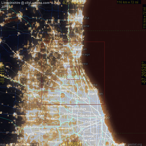
Analysis of Lincolnshire night lights 2016
Square area 10x10 km:
 21.97%
90-99
22.27%80-89
9.7%70-79
6.52%60-69
27.73%50-59
11.67%40-49
0.15%30-39
0%20-29
0%10-19
0%0-9
0%Square area 50x50 km:
16.3%90-99
13.88%80-89
8.26%70-79
7.48%60-69
9.83%50-59
9.26%40-49
5.99%30-39
3.34%20-29
3.89%10-19
3.15%0-9
18.63%Clear (daylight) street map image can be seen on geolist.org.
Map coordinates:
42° 42' 31.8" North, 88° 36' 41.5" West
42° 11' 24.1" North, 87° 54' 30.2" West
41° 40' 0.9" North, 87° 12' 19" West
Some cities around Lincolnshire sort by population:
• Buffalo Grove
6 km =3.7 mi,  224°
224°
• Wheeling
5.9 km =3.7 mi,  196°
196°
• Highland Park
9 km =5.6 mi,  95°
95°
• Vernon Hills
6.7 km =4.2 mi,  299°
299°
• Lake Forest
9.5 km =5.9 mi,  36°
36°
• Deerfield
5.7 km =3.5 mi,  111°
111°
• Long Grove
7.5 km =4.7 mi,  260°
260°
• Highwood
8.2 km =5.1 mi,  82°
82°
4899983 (p: 7,282)
Sources (retrieved 2019-11-25):
» Earth at Night: Flat Maps 2012, 2016