Hermantown night lights from space
Night Light of Hermantown (Minnesota) from space (United States) Src. Average luminocity for 10x10km area is 21.3943% and for 50x50km: 8.1701%.
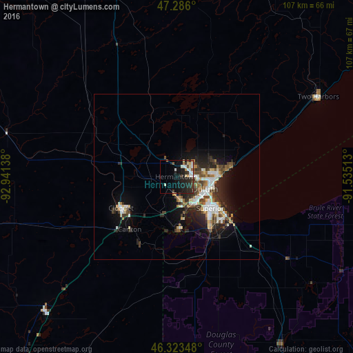
Analysis of Hermantown night lights 2016
Square area 10x10 km:
 4.17%
4.17%90-99
3.72%80-89
1.93%70-79
1.93%60-69
0.74%50-59
2.08%40-49
2.38%30-39
2.98%20-29
10.57%10-19
21.43%0-9
48.07%Square area 50x50 km:
1.32%90-99
1.61%80-89
0.67%70-79
0.75%60-69
0.82%50-59
0.96%40-49
1.31%30-39
1.5%20-29
2.91%10-19
5.18%0-9
82.96%Clear (daylight) street map image can be seen on geolist.org.
Map coordinates:
47° 17' 9.6" North, 92° 56' 29" West
46° 48' 24.8" North, 92° 14' 17.7" West
46° 19' 24.5" North, 91° 32' 6.5" West
Some cities around Hermantown sort by population:
• Duluth
10.4 km =6.5 mi,  104°
104°
• Superior
14 km =8.7 mi,  133°
133°
• Hibbing
86.9 km =54 mi,  322°
322°
• Cloquet
19.3 km =12 mi,  240°
240°
• Grand Rapids
109 km =67.7 mi,  296°
296°
• Virginia
82.8 km =51.4 mi,  344°
344°
• Rice Lake
149.7 km =93 mi,  165°
165°
• Ashland
106 km =65.9 mi, 102°
5029952 (p: 9,706)
Sources (retrieved 2019-11-25):
» Earth at Night: Flat Maps 2012, 2016