Saint John night lights from space
Night Light of Saint John (Indiana) from space (United States) Src. Average luminocity for 10x10km area is 55.3571% and for 50x50km: 46.5769%.
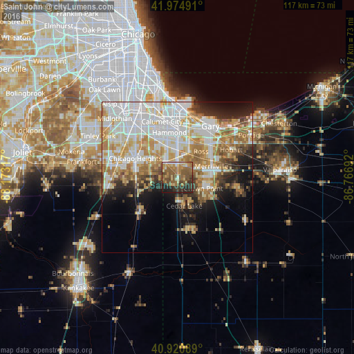
Analysis of Saint John night lights 2016
Square area 10x10 km:
 2.21%
2.21%90-99
5.61%80-89
6.97%70-79
9.69%60-69
16.33%50-59
21.94%40-49
11.73%30-39
10.88%20-29
10.54%10-19
4.08%0-9
0%Square area 50x50 km:
12.79%90-99
10.66%80-89
6.49%70-79
6.75%60-69
7%50-59
4.92%40-49
3.12%30-39
3.4%20-29
5.45%10-19
8.14%0-9
31.3%Clear (daylight) street map image can be seen on geolist.org.
Map coordinates:
41° 58' 29.7" North, 88° 10' 23.4" West
41° 27' 0.1" North, 87° 28' 12.1" West
40° 55' 15.2" North, 86° 46' 0.9" West
Some cities around Saint John sort by population:
• Crown Point
9.5 km =5.9 mi,  112°
112°
• Schererville
3.5 km =2.2 mi,  21°
21°
• Highland
11.6 km =7.2 mi,  7°
7°
• Griffith
9.5 km =5.9 mi, 23°
• Dyer
6.5 km =4 mi,  318°
318°
• Cedar Lake
9.8 km =6.1 mi,  165°
165°
• Sauk Village
9.2 km =5.7 mi,  297°
297°
• Lynwood
10.2 km =6.3 mi,  326°
326°
4925793 (p: 14,850)
Sources (retrieved 2019-11-25):
» Earth at Night: Flat Maps 2012, 2016