Dyer night lights from space
Night Light of Dyer (Indiana) from space (United States) Src. Average luminocity for 10x10km area is 74.9779% and for 50x50km: 53.4472%.
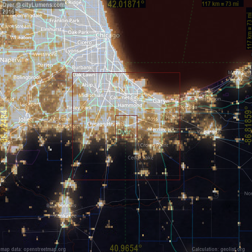
Analysis of Dyer night lights 2016
Square area 10x10 km:
 11.22%
90-99
15.48%80-89
14.12%70-79
19.05%60-69
18.37%50-59
12.07%40-49
7.65%30-39
1.87%20-29
0.17%10-19
0%0-9
0%Square area 50x50 km:
16.71%90-99
12.62%80-89
6.82%70-79
7.38%60-69
7.4%50-59
4.92%40-49
3.26%30-39
3.66%20-29
5.17%10-19
7.66%0-9
24.4%Clear (daylight) street map image can be seen on geolist.org.
Map coordinates:
42° 1' 7.4" North, 88° 13' 29.4" West
41° 29' 39.1" North, 87° 31' 18.2" West
40° 57' 55.4" North, 86° 49' 6.9" West
Some cities around Dyer sort by population:
• Schererville
5.8 km =3.6 mi,  106°
106°
• Lansing
8 km =5 mi,  349°
349°
• Munster
7.9 km =4.9 mi,  5°
5°
• Highland
8.8 km =5.5 mi,  41°
41°
• Saint John
6.5 km =4 mi,  138°
138°
• Sauk Village
3.9 km =2.4 mi,  260°
260°
• Lynwood
3.9 km =2.4 mi,  338°
338°
• Glenwood
8.6 km =5.3 mi,  308°
308°
4919820 (p: 16,051)
Sources (retrieved 2019-11-25):
» Earth at Night: Flat Maps 2012, 2016