Granville night lights from space
Night Light of Granville (Ohio) from space (United States) Src. Average luminocity for 10x10km area is 26.0519% and for 50x50km: 15.1254%.
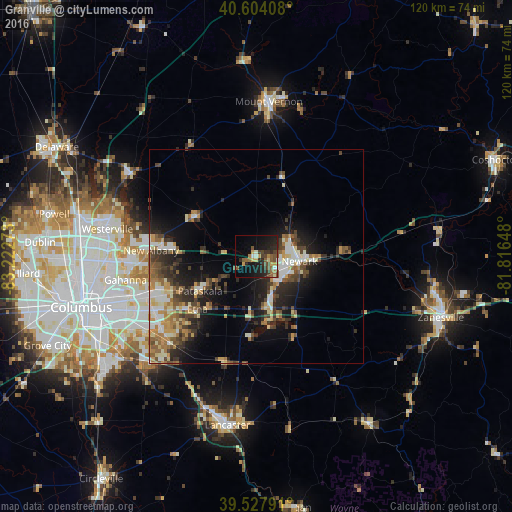
Analysis of Granville night lights 2016
Square area 10x10 km:
 0.97%
0.97%90-99
2.6%80-89
2.6%70-79
3.57%60-69
3.73%50-59
6.98%40-49
5.84%30-39
3.73%20-29
11.36%10-19
21.92%0-9
36.69%Square area 50x50 km:
1.69%90-99
2.43%80-89
1.77%70-79
2.15%60-69
2.02%50-59
2.44%40-49
2.6%30-39
2.77%20-29
4.63%10-19
8.25%0-9
69.26%Clear (daylight) street map image can be seen on geolist.org.
Map coordinates:
40° 36' 14.7" North, 83° 13' 21.8" West
40° 4' 5.2" North, 82° 31' 10.6" West
39° 31' 40.5" North, 81° 48' 59.3" West
Some cities around Granville sort by population:
• Newark
10.1 km =6.3 mi,  96°
96°
• Reynoldsburg
27.9 km =17.3 mi,  243°
243°
• Gahanna
31.1 km =19.3 mi,  259°
259°
• Pickerington
28.6 km =17.8 mi,  224°
224°
• Whitehall
33.1 km =20.6 mi,  250°
250°
• Pataskala
15.4 km =9.6 mi, 238°
• Heath
8.1 km =5 mi,  128°
128°
• New Albany
24.6 km =15.3 mi,  273°
273°
5156270 (p: 5,747)
Sources (retrieved 2019-11-25):
» Earth at Night: Flat Maps 2012, 2016