Whitehall night lights from space
Night Light of Whitehall (Ohio) from space (United States) Src. Average luminocity for 10x10km area is 98.1259% and for 50x50km: 53.4225%.
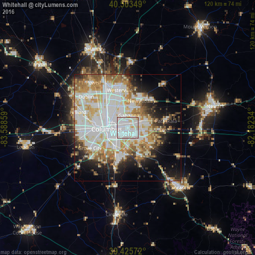
Analysis of Whitehall night lights 2016
Square area 10x10 km:
 54.93%
90-99
39.46%80-89
4.42%70-79
1.19%60-69
0%50-59
0%40-49
0%30-39
0%20-29
0%10-19
0%0-9
0%Square area 50x50 km:
16.71%90-99
14.63%80-89
5.74%70-79
6.52%60-69
6.15%50-59
4.67%40-49
3.46%30-39
3.74%20-29
5.7%10-19
8.99%0-9
23.69%Clear (daylight) street map image can be seen on geolist.org.
Map coordinates:
40° 30' 12.6" North, 83° 35' 18.9" West
39° 58' 0.2" North, 82° 53' 7.7" West
39° 25' 32.6" North, 82° 10' 56.4" West
Some cities around Whitehall sort by population:
• Columbus
9.7 km =6 mi,  266°
266°
• Reynoldsburg
6.4 km =4 mi,  101°
101°
• Gahanna
5.9 km =3.7 mi,  5°
5°
• Bexley
4.5 km =2.8 mi, 273°
• New Albany
14.3 km =8.9 mi,  27°
27°
• Blacklick Estates
7.1 km =4.4 mi,  165°
165°
• Grandview Heights
13.3 km =8.3 mi,  276°
276°
• Groveport
9.8 km =6.1 mi,  179°
179°
4528291 (p: 18,694)
Sources (retrieved 2019-11-25):
» Earth at Night: Flat Maps 2012, 2016