New Albany night lights from space
Night Light of New Albany (Ohio) from space (United States) Src. Average luminocity for 10x10km area is 62.4578% and for 50x50km: 44.9302%.
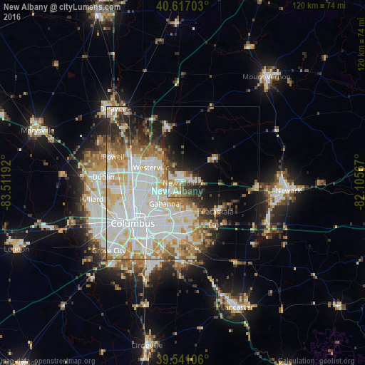
Analysis of New Albany night lights 2016
Square area 10x10 km:
 13.15%
90-99
16.4%80-89
5.84%70-79
6.01%60-69
10.55%50-59
9.58%40-49
7.79%30-39
12.5%20-29
12.82%10-19
5.36%0-9
0%Square area 50x50 km:
14.3%90-99
12.36%80-89
4.82%70-79
5.28%60-69
4.84%50-59
3.73%40-49
2.76%30-39
3.28%20-29
5.5%10-19
6.98%0-9
36.14%Clear (daylight) street map image can be seen on geolist.org.
Map coordinates:
40° 37' 1.3" North, 83° 30' 42.9" West
40° 4' 52.2" North, 82° 48' 31.6" West
39° 32' 27.8" North, 82° 6' 20.4" West
Some cities around New Albany sort by population:
• Westerville
11.4 km =7.1 mi,  296°
296°
• Reynoldsburg
14.1 km =8.8 mi,  181°
181°
• Gahanna
9.1 km =5.7 mi,  221°
221°
• Whitehall
14.3 km =8.9 mi,  207°
207°
• Pataskala
14.9 km =9.3 mi,  129°
129°
• Worthington
17.8 km =11.1 mi,  274°
274°
• Bexley
16.6 km =10.3 mi, 221°
• Sunbury
18.4 km =11.4 mi,  346°
346°
5164202 (p: 9,879)
Sources (retrieved 2019-11-25):
» Earth at Night: Flat Maps 2012, 2016