Pickerington night lights from space
Night Light of Pickerington (Ohio) from space (United States) Src. Average luminocity for 10x10km area is 57.2806% and for 50x50km: 39.272%.
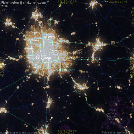
Analysis of Pickerington night lights 2016
Square area 10x10 km:
 4.93%
4.93%90-99
8.84%80-89
6.63%70-79
16.84%60-69
14.63%50-59
12.41%40-49
8.67%30-39
5.44%20-29
9.01%10-19
9.18%0-9
3.4%Square area 50x50 km:
11.64%90-99
9.77%80-89
4.21%70-79
4.57%60-69
4.41%50-59
3.24%40-49
2.78%30-39
3.59%20-29
5.91%10-19
10.69%0-9
39.18%Clear (daylight) street map image can be seen on geolist.org.
Map coordinates:
40° 25' 17.9" North, 83° 27' 23.9" West
39° 53' 3.2" North, 82° 45' 12.6" West
39° 20' 33.3" North, 82° 3' 1.4" West
Some cities around Pickerington sort by population:
• Reynoldsburg
9.3 km =5.8 mi,  327°
327°
• Gahanna
18.4 km =11.4 mi,  324°
324°
• Whitehall
14.5 km =9 mi,  309°
309°
• Pataskala
14.1 km =8.8 mi,  28°
28°
• Bexley
18.3 km =11.4 mi,  300°
300°
• Blacklick Estates
9.7 km =6 mi,  283°
283°
• Canal Winchester
6.3 km =3.9 mi,  223°
223°
• Groveport
11.1 km =6.9 mi,  266°
266°
4521209 (p: 19,745)
Sources (retrieved 2019-11-25):
» Earth at Night: Flat Maps 2012, 2016