Gahanna night lights from space
Night Light of Gahanna (Ohio) from space (United States) Src. Average luminocity for 10x10km area is 93.4805% and for 50x50km: 54.1611%.
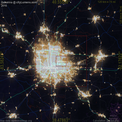

Analysis of Gahanna night lights 2016
Square area 10x10 km:
 37.82%
90-99
39.45%80-89
10.39%70-79
6.17%60-69
6.17%50-59
0%40-49
0%30-39
0%20-29
0%10-19
0%0-9
0%Square area 50x50 km:
16.8%90-99
14.74%80-89
5.8%70-79
6.47%60-69
6.36%50-59
4.68%40-49
3.96%30-39
4.31%20-29
6.85%10-19
8.06%0-9
21.97%Clear (daylight) street map image can be seen on geolist.org.
Map coordinates:
40° 33' 20.1" North, 83° 34' 56.9" West
40° 1' 9.2" North, 82° 52' 45.6" West
39° 28' 43.1" North, 82° 10' 34.4" West
Some cities around Gahanna sort by population:
• Columbus
12.1 km =7.5 mi,  237°
237°
• Westerville
12.6 km =7.8 mi,  340°
340°
• Reynoldsburg
9.2 km =5.7 mi,  141°
141°
• Whitehall
5.9 km =3.7 mi,  185°
185°
• Bexley
7.5 km =4.7 mi,  221°
221°
• New Albany
9.1 km =5.7 mi,  41°
41°
• Blacklick Estates
12.8 km =8 mi,  174°
174°
• Grandview Heights
14.4 km =8.9 mi,  252°
252°
5155393 (p: 34,590)
Sources (retrieved 2019-11-25):
» Earth at Night: Flat Maps 2012, 2016