Pataskala night lights from space
Night Light of Pataskala (Ohio) from space (United States) Src. Average luminocity for 10x10km area is 34.4881% and for 50x50km: 34.261%.
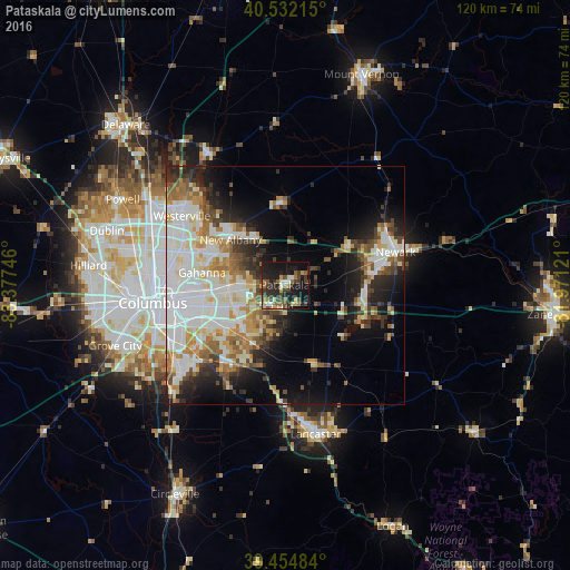
Analysis of Pataskala night lights 2016
Square area 10x10 km:
 2.04%
2.04%90-99
4.25%80-89
2.04%70-79
5.61%60-69
6.12%50-59
6.8%40-49
5.44%30-39
10.88%20-29
14.97%10-19
32.65%0-9
9.18%Square area 50x50 km:
8.36%90-99
8.75%80-89
3.44%70-79
3.81%60-69
4.24%50-59
3.51%40-49
3.4%30-39
3.75%20-29
6.51%10-19
10.72%0-9
43.49%Clear (daylight) street map image can be seen on geolist.org.
Map coordinates:
40° 31' 55.7" North, 83° 22' 38.9" West
39° 59' 44.2" North, 82° 40' 27.6" West
39° 27' 17.4" North, 81° 58' 16.4" West
Some cities around Pataskala sort by population:
• Reynoldsburg
12.6 km =7.8 mi,  248°
248°
• Gahanna
17.7 km =11 mi,  278°
278°
• Pickerington
14.1 km =8.8 mi,  208°
208°
• Whitehall
18.3 km =11.4 mi,  259°
259°
• Heath
19.8 km =12.3 mi,  81°
81°
• New Albany
14.9 km =9.3 mi,  309°
309°
• Blacklick Estates
19.1 km =11.9 mi,  238°
238°
• Granville
15.4 km =9.6 mi,  58°
58°
4520905 (p: 15,245)
Sources (retrieved 2019-11-25):
» Earth at Night: Flat Maps 2012, 2016