Foster City night lights from space
Night Light of Foster City (California) from space (United States) Src. Average luminocity for 10x10km area is 61.1964% and for 50x50km: 39.4966%.
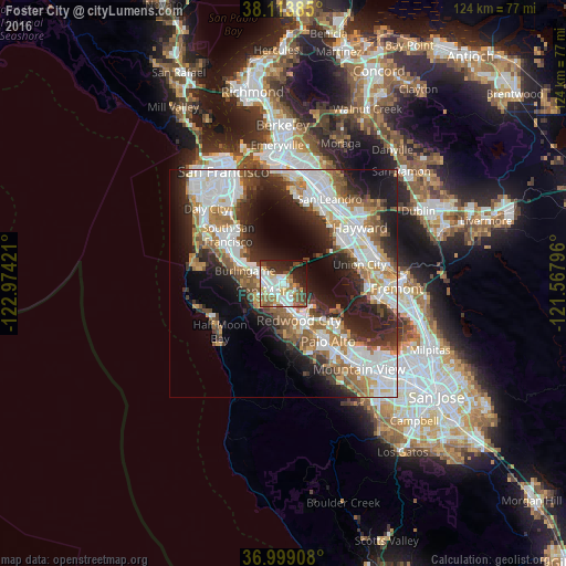

Analysis of Foster City night lights 2016
Square area 10x10 km:
 13.96%
90-99
18.02%80-89
4.38%70-79
7.95%60-69
6.98%50-59
9.25%40-49
9.58%30-39
4.87%20-29
13.15%10-19
10.06%0-9
1.79%Square area 50x50 km:
10.3%90-99
9.04%80-89
2.19%70-79
4.81%60-69
5.26%50-59
5.5%40-49
4.45%30-39
4.72%20-29
9.73%10-19
12.82%0-9
31.18%Clear (daylight) street map image can be seen on geolist.org.
Map coordinates:
38° 6' 49.9" North, 122° 58' 27.2" West
37° 33' 30.8" North, 122° 16' 15.9" West
36° 59' 56.7" North, 121° 34' 4.7" West
Some cities around Foster City sort by population:
• San Mateo
4.8 km =3 mi,  275°
275°
• Redwood City
8.7 km =5.4 mi,  159°
159°
• Burlingame
8.8 km =5.5 mi,  288°
288°
• San Carlos
5.8 km =3.6 mi,  170°
170°
• Belmont
4.3 km =2.7 mi,  185°
185°
• Millbrae
11.2 km =7 mi, 293°
• Hillsborough
9.7 km =6 mi, 280°
• Redwood Shores
3.6 km =2.2 mi,  145°
145°
5350159 (p: 33,477)
Sources (retrieved 2019-11-25):
» Earth at Night: Flat Maps 2012, 2016