Estes Park night lights from space
Night Light of Estes Park (Colorado) from space (United States) Src. Average luminocity for 10x10km area is 14.3895% and for 50x50km: 0.7365%.
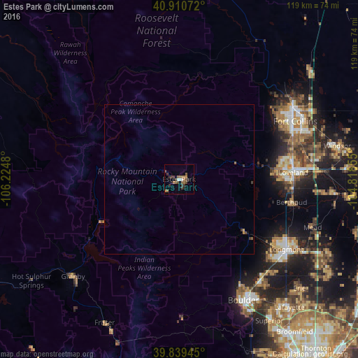
Analysis of Estes Park night lights 2016
Square area 10x10 km:
 1.02%
1.02%90-99
1.02%80-89
0%70-79
2.21%60-69
4.42%50-59
2.89%40-49
4.08%30-39
4.08%20-29
1.7%10-19
0.68%0-9
77.89%Square area 50x50 km:
0.04%90-99
0.04%80-89
0%70-79
0.13%60-69
0.22%50-59
0.14%40-49
0.18%30-39
0.26%20-29
0.07%10-19
0.05%0-9
98.87%Clear (daylight) street map image can be seen on geolist.org.
Map coordinates:
40° 54' 38.6" North, 106° 13' 29.3" West
40° 22' 38" North, 105° 31' 18" West
39° 50' 22" North, 104° 49' 6.8" West
Some cities around Estes Park sort by population:
• Fort Collins
43.6 km =27.1 mi,  57°
57°
• Boulder
45.6 km =28.3 mi,  152°
152°
• Longmont
42.6 km =26.5 mi,  123°
123°
• Loveland
37.9 km =23.5 mi,  86°
86°
• Windsor
53.7 km =33.4 mi,  78°
78°
• Johnstown
51.8 km =32.2 mi, 94°
• Gunbarrel
45.9 km =28.5 mi,  139°
139°
• Berthoud
38.1 km =23.7 mi,  101°
101°
5576882 (p: 6,257)
Sources (retrieved 2019-11-25):
» Earth at Night: Flat Maps 2012, 2016