Gunbarrel night lights from space
Night Light of Gunbarrel (Colorado) from space (United States) Src. Average luminocity for 10x10km area is 34.0552% and for 50x50km: 26.8378%.
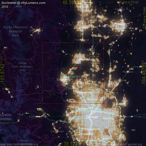
Analysis of Gunbarrel night lights 2016
Square area 10x10 km:
 3.41%
3.41%90-99
2.11%80-89
2.92%70-79
7.79%60-69
4.06%50-59
4.87%40-49
4.22%30-39
6.66%20-29
21.59%10-19
41.23%0-9
1.14%Square area 50x50 km:
3.51%90-99
4.13%80-89
4.53%70-79
5.13%60-69
4.34%50-59
4.34%40-49
3.29%30-39
3.24%20-29
6.18%10-19
13.28%0-9
48.02%Clear (daylight) street map image can be seen on geolist.org.
Map coordinates:
40° 35' 57.7" North, 105° 52' 27.1" West
40° 3' 48.1" North, 105° 10' 15.9" West
39° 31' 23.2" North, 104° 28' 4.6" West
Some cities around Gunbarrel sort by population:
• Boulder
10 km =6.2 mi,  237°
237°
• Longmont
13 km =8.1 mi,  26°
26°
• Broomfield
17.4 km =10.8 mi,  155°
155°
• Lafayette
10.4 km =6.5 mi,  138°
138°
• Erie
10.4 km =6.5 mi,  98°
98°
• Louisville
10.1 km =6.3 mi, 160°
• Superior
12.3 km =7.6 mi,  179°
179°
• Frederick
20.3 km =12.6 mi,  78°
78°
7261393 (p: 9,263)
Sources (retrieved 2019-11-25):
» Earth at Night: Flat Maps 2012, 2016