Berthoud night lights from space
Night Light of Berthoud (Colorado) from space (United States) Src. Average luminocity for 10x10km area is 13.8044% and for 50x50km: 18.8536%.
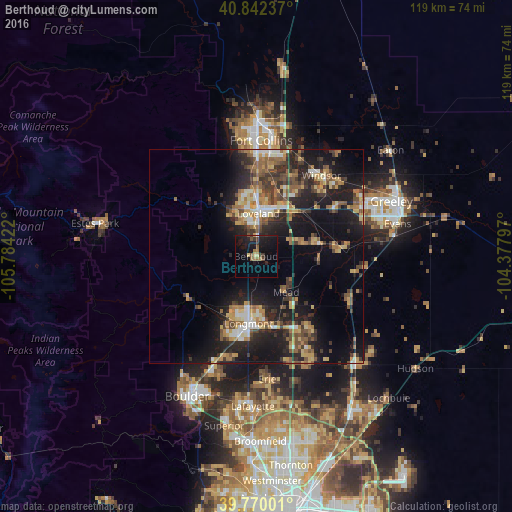
Analysis of Berthoud night lights 2016
Square area 10x10 km:
 0%
0%90-99
0.34%80-89
2.04%70-79
0.34%60-69
3.4%50-59
2.04%40-49
2.55%30-39
2.89%20-29
2.89%10-19
22.62%0-9
60.88%Square area 50x50 km:
1.49%90-99
1.99%80-89
2.4%70-79
2.85%60-69
3.19%50-59
3.22%40-49
2.88%30-39
4.34%20-29
6.17%10-19
15.24%0-9
56.23%Clear (daylight) street map image can be seen on geolist.org.
Map coordinates:
40° 50' 32.5" North, 105° 47' 3.2" West
40° 18' 30" North, 105° 4' 51.9" West
39° 46' 12" North, 104° 22' 40.7" West
Some cities around Berthoud sort by population:
• Longmont
15.8 km =9.8 mi,  186°
186°
• Loveland
10 km =6.2 mi,  2°
2°
• Windsor
24.2 km =15 mi,  38°
38°
• Johnstown
14.7 km =9.1 mi,  77°
77°
• Firestone
25 km =15.5 mi,  150°
150°
• Frederick
26.3 km =16.3 mi, 152°
• Gunbarrel
28.3 km =17.6 mi,  195°
195°
• Milliken
19.3 km =12 mi, 83°
5574704 (p: 6,031)
Sources (retrieved 2019-11-25):
» Earth at Night: Flat Maps 2012, 2016