Johnstown night lights from space
Night Light of Johnstown (Colorado) from space (United States) Src. Average luminocity for 10x10km area is 18.1088% and for 50x50km: 23.7422%.
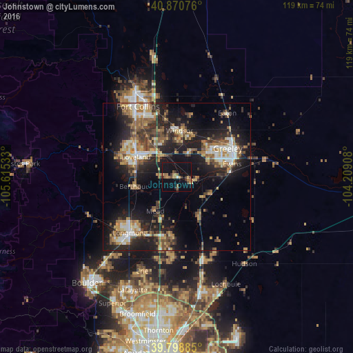
Analysis of Johnstown night lights 2016
Square area 10x10 km:
 0.34%
0.34%90-99
0.34%80-89
2.04%70-79
3.4%60-69
5.44%50-59
2.04%40-49
1.36%30-39
5.1%20-29
0.68%10-19
15.48%0-9
63.78%Square area 50x50 km:
2.49%90-99
3.09%80-89
2.98%70-79
3.22%60-69
3.98%50-59
3.86%40-49
3.4%30-39
4.73%20-29
7.7%10-19
16.32%0-9
48.23%Clear (daylight) street map image can be seen on geolist.org.
Map coordinates:
40° 52' 14.7" North, 105° 36' 55.2" West
40° 20' 12.9" North, 104° 54' 43.9" West
39° 47' 55.9" North, 104° 12' 32.7" West
Some cities around Johnstown sort by population:
• Greeley
19.7 km =12.2 mi,  60°
60°
• Longmont
24.8 km =15.4 mi,  220°
220°
• Loveland
15.4 km =9.6 mi,  296°
296°
• Windsor
15.7 km =9.8 mi,  3°
3°
• Evans
19.2 km =11.9 mi,  76°
76°
• Firestone
25 km =15.5 mi,  184°
184°
• Milliken
4.9 km =3 mi,  99°
99°
• Berthoud
14.7 km =9.1 mi,  257°
257°
5578536 (p: 14,896)
Sources (retrieved 2019-11-25):
» Earth at Night: Flat Maps 2012, 2016