Elwood night lights from space
Night Light of Elwood (New York) from space (United States) Src. Average luminocity for 10x10km area is 73.8759% and for 50x50km: 49.0896%.
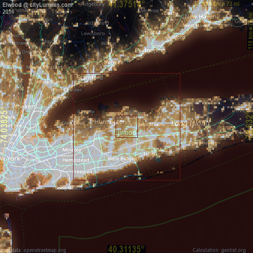
Analysis of Elwood night lights 2016
Square area 10x10 km:
 8.16%
8.16%90-99
12.24%80-89
10.03%70-79
22.45%60-69
33.5%50-59
12.76%40-49
0.85%30-39
0%20-29
0%10-19
0%0-9
0%Square area 50x50 km:
13.16%90-99
11.39%80-89
6.25%70-79
8.73%60-69
7.05%50-59
5.77%40-49
3.27%30-39
2.49%20-29
5.44%10-19
8.77%0-9
27.68%Clear (daylight) street map image can be seen on geolist.org.
Map coordinates:
41° 22' 30.5" North, 74° 2' 17.7" West
40° 50' 43.4" North, 73° 20' 6.4" West
40° 18' 40.9" North, 72° 37' 55.2" West
Some cities around Elwood sort by population:
• Commack
3.6 km =2.2 mi,  94°
94°
• Huntington Station
6.5 km =4 mi,  277°
277°
• Dix Hills
4.5 km =2.8 mi,  181°
181°
• East Northport
3.6 km =2.2 mi,  14°
14°
• Greenlawn
3.6 km =2.2 mi,  316°
316°
• South Huntington
5.9 km =3.7 mi,  245°
245°
• Northport
6.2 km =3.9 mi,  353°
353°
• Centerport
5.6 km =3.5 mi, 322°
5116550 (p: 11,177)
Sources (retrieved 2019-11-25):
» Earth at Night: Flat Maps 2012, 2016