Eatonton night lights from space
Night Light of Eatonton (Georgia) from space (United States) Src. Average luminocity for 10x10km area is 21.271% and for 50x50km: 4.5641%.
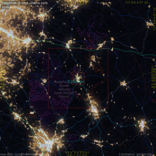
Analysis of Eatonton night lights 2016
Square area 10x10 km:
 0.7%
0.7%90-99
1.4%80-89
2.97%70-79
5.94%60-69
3.5%50-59
3.85%40-49
2.1%30-39
5.24%20-29
1.4%10-19
13.11%0-9
59.79%Square area 50x50 km:
0.14%90-99
0.21%80-89
0.52%70-79
0.73%60-69
0.68%50-59
0.62%40-49
0.95%30-39
1.63%20-29
0.87%10-19
2.84%0-9
90.8%Clear (daylight) street map image can be seen on geolist.org.
Map coordinates:
33° 54' 44.3" North, 84° 5' 29.9" West
33° 19' 36.5" North, 83° 23' 18.6" West
32° 44' 14.4" North, 82° 41' 7.4" West
Some cities around Eatonton sort by population:
• Athens
70.5 km =43.8 mi,  0°
0°
• Macon
58.6 km =36.4 mi,  202°
202°
• Milledgeville
31 km =19.3 mi,  152°
152°
• Conyers
69.6 km =43.2 mi,  303°
303°
• Covington
53.1 km =33 mi, 304°
• Monroe
60.1 km =37.3 mi,  329°
329°
• Locust Grove
67 km =41.6 mi,  271°
271°
• Sandersville
66.1 km =41.1 mi,  125°
125°
4192800 (p: 6,520)
Sources (retrieved 2019-11-25):
» Earth at Night: Flat Maps 2012, 2016