Monroe night lights from space
Night Light of Monroe (Georgia) from space (United States) Src. Average luminocity for 10x10km area is 46.9983% and for 50x50km: 33.3049%.
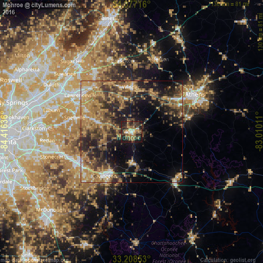
Analysis of Monroe night lights 2016
Square area 10x10 km:
 2.97%
2.97%90-99
4.37%80-89
7.69%70-79
6.82%60-69
10.49%50-59
9.09%40-49
10.31%30-39
15.03%20-29
18.01%10-19
14.86%0-9
0.35%Square area 50x50 km:
2.06%90-99
2.54%80-89
5%70-79
7.88%60-69
7.66%50-59
5.93%40-49
6.76%30-39
7.66%20-29
8.73%10-19
14.18%0-9
31.6%Clear (daylight) street map image can be seen on geolist.org.
Map coordinates:
34° 22' 37.8" North, 84° 24' 58.9" West
33° 47' 41.4" North, 83° 42' 47.6" West
33° 12' 30.7" North, 83° 0' 36.4" West
Some cities around Monroe sort by population:
• Lawrenceville
31.1 km =19.3 mi,  305°
305°
• Snellville
29.2 km =18.1 mi,  283°
283°
• Conyers
31.5 km =19.6 mi,  243°
243°
• Winder
22 km =13.7 mi,  358°
358°
• Covington
25.9 km =16.1 mi,  211°
211°
• Loganville
18 km =11.2 mi,  285°
285°
• Auburn
26.5 km =16.5 mi,  336°
336°
• Dacula
27.5 km =17.1 mi,  321°
321°
4209884 (p: 13,641)
Sources (retrieved 2019-11-25):
» Earth at Night: Flat Maps 2012, 2016