Locust Grove night lights from space
Night Light of Locust Grove (Georgia) from space (United States) Src. Average luminocity for 10x10km area is 54.1836% and for 50x50km: 40.0954%.
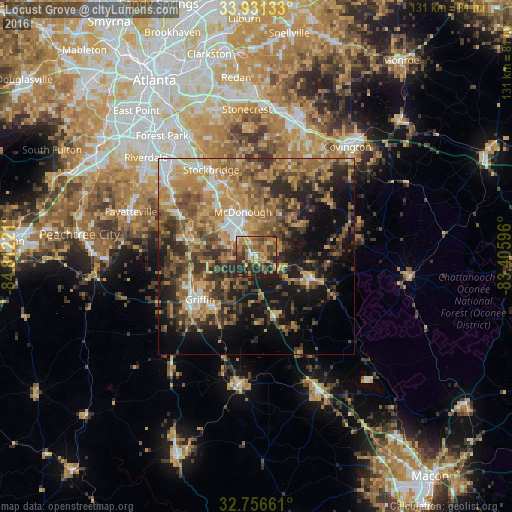
Analysis of Locust Grove night lights 2016
Square area 10x10 km:
 2.1%
2.1%90-99
5.59%80-89
8.57%70-79
11.89%60-69
15.73%50-59
12.76%40-49
12.76%30-39
8.92%20-29
18.88%10-19
2.8%0-9
0%Square area 50x50 km:
3.48%90-99
3.81%80-89
5.02%70-79
9.64%60-69
9.25%50-59
7.9%40-49
7.78%30-39
8.41%20-29
8.88%10-19
13.77%0-9
22.05%Clear (daylight) street map image can be seen on geolist.org.
Map coordinates:
33° 55' 52.8" North, 84° 48' 44" West
33° 20' 45.4" North, 84° 6' 32.7" West
32° 45' 23.8" North, 83° 24' 21.5" West
Some cities around Locust Grove sort by population:
• Stockbridge
24.9 km =15.5 mi,  332°
332°
• McDonough
11.8 km =7.3 mi,  342°
342°
• Griffin
18.1 km =11.2 mi,  232°
232°
• Irondale
27.6 km =17.1 mi,  302°
302°
• Hampton
16.8 km =10.4 mi,  285°
285°
• Morrow
33.9 km =21.1 mi,  320°
320°
• Barnesville
32.7 km =20.3 mi,  187°
187°
• Lovejoy
21.5 km =13.4 mi, 297°
4206502 (p: 5,790)
Sources (retrieved 2019-11-25):
» Earth at Night: Flat Maps 2012, 2016