Conyers night lights from space
Night Light of Conyers (Georgia) from space (United States) Src. Average luminocity for 10x10km area is 80.5604% and for 50x50km: 59.0866%.
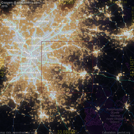
Analysis of Conyers night lights 2016
Square area 10x10 km:
 19.96%
90-99
19.05%80-89
6.41%70-79
18.86%60-69
30.22%50-59
3.85%40-49
1.28%30-39
0.37%20-29
0%10-19
0%0-9
0%Square area 50x50 km:
7.86%90-99
9.12%80-89
10.17%70-79
16.09%60-69
14.62%50-59
7.73%40-49
6.61%30-39
6.37%20-29
7.42%10-19
7.23%0-9
6.79%Clear (daylight) street map image can be seen on geolist.org.
Map coordinates:
34° 15' 2.9" North, 84° 43' 15" West
33° 40' 3.4" North, 84° 1' 3.7" West
33° 4' 49.6" North, 83° 18' 52.5" West
Some cities around Conyers sort by population:
• Stonecrest
11.8 km =7.3 mi,  292°
292°
• Redan
13.6 km =8.5 mi,  309°
309°
• Snellville
21.1 km =13.1 mi,  359°
359°
• Covington
16.6 km =10.3 mi,  118°
118°
• Mountain Park
22.2 km =13.8 mi,  332°
332°
• Loganville
21.9 km =13.6 mi,  29°
29°
• Panthersville
23.9 km =14.9 mi,  280°
280°
• Stone Mountain
21 km =13 mi,  317°
317°
4189213 (p: 15,875)
Sources (retrieved 2019-11-25):
» Earth at Night: Flat Maps 2012, 2016