Bronxville night lights from space
Night Light of Bronxville (New York) from space (United States) Src. Average luminocity for 10x10km area is 94.7517% and for 50x50km: 72.6079%.
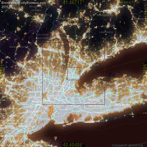
Analysis of Bronxville night lights 2016
Square area 10x10 km:
 46.6%
46.6%90-99
32.65%80-89
8.84%70-79
11.05%60-69
0.85%50-59
0%40-49
0%30-39
0%20-29
0%10-19
0%0-9
0%Square area 50x50 km:
27.54%90-99
15.65%80-89
6.95%70-79
9.07%60-69
12.36%50-59
6.88%40-49
4.3%30-39
4.39%20-29
5.22%10-19
4.72%0-9
2.94%Clear (daylight) street map image can be seen on geolist.org.
Map coordinates:
41° 28' 1.8" North, 74° 32' 6.8" West
40° 56' 17.3" North, 73° 49' 55.5" West
40° 24' 17.5" North, 73° 7' 44.3" West
Some cities around Bronxville sort by population:
• New Rochelle
5.1 km =3.2 mi,  125°
125°
• Mount Vernon
2.9 km =1.8 mi,  188°
188°
• Wakefield
4.8 km =3 mi,  200°
200°
• Eastchester
3 km =1.9 mi,  41°
41°
• Wykagyl
2.8 km =1.7 mi,  82°
82°
• Pelham
3.7 km =2.3 mi,  147°
147°
• Tuckahoe
1.4 km =0.9 mi,  16°
16°
• Pelham Manor
5.2 km =3.2 mi,  156°
156°
5110269 (p: 6,438)
Sources (retrieved 2019-11-25):
» Earth at Night: Flat Maps 2012, 2016