East Moriches night lights from space
Night Light of East Moriches (New York) from space (United States) Src. Average luminocity for 10x10km area is 35.1054% and for 50x50km: 18.3557%.
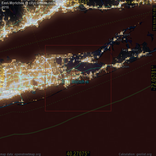
Analysis of East Moriches night lights 2016
Square area 10x10 km:
 0.85%
0.85%90-99
2.04%80-89
4.93%70-79
5.27%60-69
9.69%50-59
7.65%40-49
9.52%30-39
8.5%20-29
9.01%10-19
26.19%0-9
16.33%Square area 50x50 km:
1.3%90-99
1.81%80-89
2.41%70-79
2.91%60-69
3.86%50-59
4.01%40-49
3.91%30-39
2.89%20-29
4.67%10-19
12.34%0-9
59.9%Clear (daylight) street map image can be seen on geolist.org.
Map coordinates:
41° 20' 6.7" North, 73° 27' 50.6" West
40° 48' 18.4" North, 72° 45' 39.3" West
40° 16' 14.7" North, 72° 3' 28.1" West
Some cities around East Moriches sort by population:
• Shirley
9 km =5.6 mi,  267°
267°
• Mastic
6.7 km =4.2 mi, 267°
• Mastic Beach
8.8 km =5.5 mi,  240°
240°
• Manorville
8.6 km =5.3 mi,  332°
332°
• Riverhead
15 km =9.3 mi,  33°
33°
• Center Moriches
2.5 km =1.6 mi,  257°
257°
• Calverton
11.4 km =7.1 mi,  7°
7°
• Yaphank
13.6 km =8.5 mi,  285°
285°
5115974 (p: 5,249)
Sources (retrieved 2019-11-25):
» Earth at Night: Flat Maps 2012, 2016