Mastic night lights from space
Night Light of Mastic (New York) from space (United States) Src. Average luminocity for 10x10km area is 53.0595% and for 50x50km: 23.6921%.
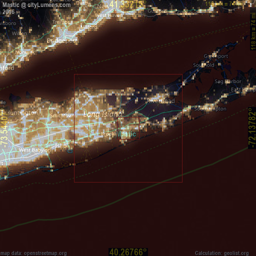
Analysis of Mastic night lights 2016
Square area 10x10 km:
 3.57%
3.57%90-99
4.93%80-89
6.97%70-79
9.52%60-69
9.52%50-59
18.54%40-49
19.22%30-39
9.18%20-29
12.24%10-19
6.29%0-9
0%Square area 50x50 km:
2.41%90-99
3.07%80-89
3.01%70-79
4.52%60-69
4.99%50-59
4.77%40-49
3.98%30-39
2.84%20-29
5.15%10-19
13.2%0-9
52.06%Clear (daylight) street map image can be seen on geolist.org.
Map coordinates:
41° 19' 55.7" North, 73° 32' 38.7" West
40° 48' 7.3" North, 72° 50' 27.4" West
40° 16' 3.6" North, 72° 8' 16.2" West
Some cities around Mastic sort by population:
• Shirley
2.2 km =1.4 mi,  268°
268°
• Manorville
8.4 km =5.2 mi,  19°
19°
• Ridge
11.2 km =7 mi,  335°
335°
• North Bellport
9.1 km =5.7 mi,  250°
250°
• Middle Island
12.2 km =7.6 mi,  318°
318°
• Center Moriches
4.3 km =2.7 mi,  92°
92°
• Yaphank
7.5 km =4.7 mi,  301°
301°
• East Moriches
6.7 km =4.2 mi, 87°
5126208 (p: 15,481)
Sources (retrieved 2019-11-25):
» Earth at Night: Flat Maps 2012, 2016