Riverhead night lights from space
Night Light of Riverhead (New York) from space (United States) Src. Average luminocity for 10x10km area is 35.1173% and for 50x50km: 13.4582%.
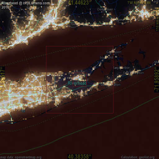
Analysis of Riverhead night lights 2016
Square area 10x10 km:
 4.25%
4.25%90-99
4.08%80-89
5.61%70-79
4.93%60-69
4.93%50-59
4.08%40-49
6.12%30-39
3.4%20-29
8.5%10-19
49.32%0-9
4.76%Square area 50x50 km:
0.51%90-99
0.82%80-89
1.78%70-79
1.99%60-69
2.08%50-59
2.91%40-49
3.65%30-39
2.8%20-29
4.31%10-19
11.79%0-9
67.37%Clear (daylight) street map image can be seen on geolist.org.
Map coordinates:
41° 26' 46.4" North, 73° 21' 54.6" West
40° 55' 1.3" North, 72° 39' 43.3" West
40° 23' 0.9" North, 71° 57' 32.1" West
Some cities around Riverhead sort by population:
• Mastic
19.7 km =12.2 mi,  229°
229°
• Manorville
13.2 km =8.2 mi,  248°
248°
• Hampton Bays
13.3 km =8.3 mi,  113°
113°
• Wading River
15.6 km =9.7 mi,  283°
283°
• Center Moriches
16.8 km =10.4 mi,  219°
219°
• East Shoreham
18.5 km =11.5 mi, 279°
• Calverton
6.9 km =4.3 mi,  260°
260°
• East Moriches
15 km =9.3 mi,  213°
213°
5133926 (p: 13,299)
Sources (retrieved 2019-11-25):
» Earth at Night: Flat Maps 2012, 2016