Dublin night lights from space
Night Light of Dublin (Georgia) from space (United States) Src. Average luminocity for 10x10km area is 57.7234% and for 50x50km: 5.0544%.
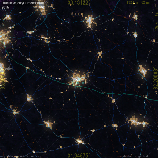
Analysis of Dublin night lights 2016
Square area 10x10 km:
 9.16%
9.16%90-99
9.89%80-89
9.71%70-79
9.34%60-69
13.74%50-59
6.78%40-49
4.95%30-39
10.44%20-29
16.48%10-19
9.34%0-9
0.18%Square area 50x50 km:
0.41%90-99
0.44%80-89
0.68%70-79
0.85%60-69
0.98%50-59
0.65%40-49
0.48%30-39
1.25%20-29
1.96%10-19
2.92%0-9
89.39%Clear (daylight) street map image can be seen on geolist.org.
Map coordinates:
33° 7' 52.4" North, 83° 36' 24.8" West
32° 32' 25.6" North, 82° 54' 13.5" West
31° 56' 44.7" North, 82° 12' 2.3" West
Some cities around Dublin sort by population:
• Warner Robins
68.2 km =42.4 mi,  277°
277°
• Milledgeville
67.4 km =41.9 mi,  332°
332°
• Vidalia
58.4 km =36.3 mi,  127°
127°
• Swainsboro
53.8 km =33.4 mi,  83°
83°
• Sandersville
49.8 km =30.9 mi,  10°
10°
• McRae
52.5 km =32.6 mi,  179°
179°
• Hawkinsville
60.5 km =37.6 mi,  241°
241°
• Eastman
46 km =28.6 mi,  214°
214°
4192205 (p: 16,197)
Sources (retrieved 2019-11-25):
» Earth at Night: Flat Maps 2012, 2016