McRae night lights from space
Night Light of McRae (Georgia) from space (United States) Src. Average luminocity for 10x10km area is 19.6101% and for 50x50km: 1.9777%.
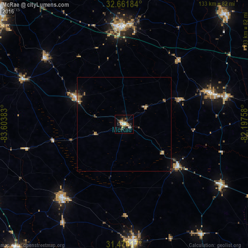
Analysis of McRae night lights 2016
Square area 10x10 km:
 1.75%
1.75%90-99
2.62%80-89
3.32%70-79
2.8%60-69
3.5%50-59
0.17%40-49
2.27%30-39
5.59%20-29
2.1%10-19
9.09%0-9
66.78%Square area 50x50 km:
0.1%90-99
0.19%80-89
0.23%70-79
0.3%60-69
0.48%50-59
0.16%40-49
0.36%30-39
0.35%20-29
0.34%10-19
0.72%0-9
96.76%Clear (daylight) street map image can be seen on geolist.org.
Map coordinates:
32° 39' 42.6" North, 83° 36' 13.8" West
32° 4' 4.6" North, 82° 54' 2.5" West
31° 28' 12.6" North, 82° 11' 51.3" West
Some cities around McRae sort by population:
• Dublin
52.5 km =32.6 mi,  359°
359°
• Douglas
62.4 km =38.8 mi,  175°
175°
• Cordele
83.9 km =52.1 mi,  262°
262°
• Vidalia
48.8 km =30.3 mi,  70°
70°
• Fitzgerald
51.4 km =31.9 mi,  220°
220°
• Swainsboro
79.4 km =49.3 mi,  42°
42°
• Hawkinsville
58.9 km =36.6 mi,  294°
294°
• Eastman
29.8 km =18.5 mi,  298°
298°
4208683 (p: 5,740)
Sources (retrieved 2019-11-25):
» Earth at Night: Flat Maps 2012, 2016