Coldwater night lights from space
Night Light of Coldwater (Michigan) from space (United States) Src. Average luminocity for 10x10km area is 49.3429% and for 50x50km: 4.2144%.
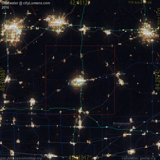
Analysis of Coldwater night lights 2016
Square area 10x10 km:
 6.83%
6.83%90-99
9.21%80-89
9.84%70-79
4.13%60-69
6.67%50-59
8.41%40-49
10%30-39
9.37%20-29
9.05%10-19
23.02%0-9
3.49%Square area 50x50 km:
0.34%90-99
0.42%80-89
0.65%70-79
0.29%60-69
0.66%50-59
0.63%40-49
0.85%30-39
1.17%20-29
1.34%10-19
2.64%0-9
91.01%Clear (daylight) street map image can be seen on geolist.org.
Map coordinates:
42° 27' 40.3" North, 85° 42' 13.1" West
41° 56' 25.2" North, 85° 0' 1.9" West
41° 24' 54.6" North, 84° 17' 50.6" West
Some cities around Coldwater sort by population:
• Battle Creek
44.4 km =27.6 mi,  340°
340°
• Sturgis
38 km =23.6 mi,  245°
245°
• Angola
34 km =21.1 mi,  179°
179°
• Albion
39.4 km =24.5 mi,  31°
31°
• Hillsdale
30.7 km =19.1 mi,  94°
94°
• Three Rivers
52.3 km =32.5 mi,  270°
270°
• Marshall
37 km =23 mi,  4°
4°
• Springfield
47.2 km =29.3 mi, 335°
4989266 (p: 10,844)
Sources (retrieved 2019-11-25):
» Earth at Night: Flat Maps 2012, 2016