Three Rivers night lights from space
Night Light of Three Rivers (Michigan) from space (United States) Src. Average luminocity for 10x10km area is 16.7762% and for 50x50km: 4.2799%.
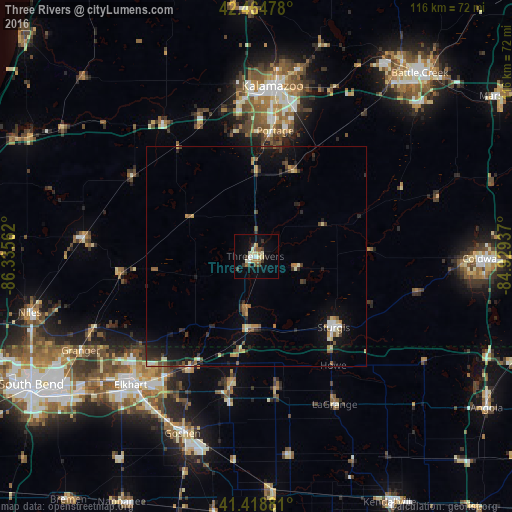
Analysis of Three Rivers night lights 2016
Square area 10x10 km:
 1.75%
1.75%90-99
2.38%80-89
3.49%70-79
1.43%60-69
2.06%50-59
1.11%40-49
1.75%30-39
4.13%20-29
1.27%10-19
7.46%0-9
73.17%Square area 50x50 km:
0.25%90-99
0.42%80-89
0.64%70-79
0.45%60-69
0.47%50-59
0.65%40-49
0.47%30-39
0.99%20-29
0.97%10-19
3.12%0-9
91.57%Clear (daylight) street map image can be seen on geolist.org.
Map coordinates:
42° 27' 53.2" North, 86° 20' 8.2" West
41° 56' 38.2" North, 85° 37' 57" West
41° 25' 7.7" North, 84° 55' 45.7" West
Some cities around Three Rivers sort by population:
• Kalamazoo
38.8 km =24.1 mi,  5°
5°
• Elkhart
40.8 km =25.4 mi,  224°
224°
• Portage
28.9 km =18 mi, 8°
• Sturgis
23.9 km =14.9 mi,  132°
132°
• Westwood
39.9 km =24.8 mi,  359°
359°
• Eastwood
40.5 km =25.2 mi, 9°
• Dunlap
41.6 km =25.8 mi, 215°
• Dowagiac
39.6 km =24.6 mi,  276°
276°
5012194 (p: 7,752)
Sources (retrieved 2019-11-25):
» Earth at Night: Flat Maps 2012, 2016