Marshall night lights from space
Night Light of Marshall (Michigan) from space (United States) Src. Average luminocity for 10x10km area is 20.0091% and for 50x50km: 6.716%.
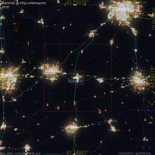
Analysis of Marshall night lights 2016
Square area 10x10 km:
 0.91%
0.91%90-99
4.09%80-89
2.88%70-79
3.48%60-69
3.48%50-59
1.52%40-49
2.88%30-39
0.45%20-29
2.58%10-19
16.06%0-9
61.67%Square area 50x50 km:
0.71%90-99
1.01%80-89
1.03%70-79
0.63%60-69
1.14%50-59
1.09%40-49
1.2%30-39
1%20-29
1.63%10-19
3.29%0-9
87.27%Clear (daylight) street map image can be seen on geolist.org.
Map coordinates:
42° 47' 25.4" North, 85° 39' 59.2" West
42° 16' 20.1" North, 84° 57' 47.9" West
41° 44' 59.4" North, 84° 15' 36.7" West
Some cities around Marshall sort by population:
• Battle Creek
18.4 km =11.4 mi,  285°
285°
• Jackson
46.3 km =28.8 mi,  93°
93°
• Coldwater
37 km =23 mi,  184°
184°
• Charlotte
34 km =21.1 mi,  17°
17°
• Albion
17.6 km =10.9 mi,  100°
100°
• Comstock Northwest
45.9 km =28.5 mi,  276°
276°
• Eaton Rapids
36.5 km =22.7 mi,  43°
43°
• Springfield
23.5 km =14.6 mi, 284°
5000996 (p: 7,045)
Sources (retrieved 2019-11-25):
» Earth at Night: Flat Maps 2012, 2016