Downingtown night lights from space
Night Light of Downingtown (Pennsylvania) from space (United States) Src. Average luminocity for 10x10km area is 51.9422% and for 50x50km: 36.5618%.
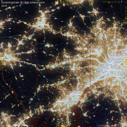
Analysis of Downingtown night lights 2016
Square area 10x10 km:
 6.8%
6.8%90-99
4.93%80-89
7.65%70-79
5.44%60-69
7.14%50-59
14.29%40-49
10.71%30-39
22.96%20-29
17.86%10-19
2.21%0-9
0%Square area 50x50 km:
3.55%90-99
3.84%80-89
5.23%70-79
5.5%60-69
7.49%50-59
10%40-49
7.33%30-39
8.16%20-29
7.33%10-19
11%0-9
30.56%Clear (daylight) street map image can be seen on geolist.org.
Map coordinates:
40° 32' 34.6" North, 76° 24' 23" West
40° 0' 23.4" North, 75° 42' 11.8" West
39° 27' 56.9" North, 75° 0' 0.5" West
Some cities around Downingtown sort by population:
• West Chester
9.6 km =6 mi,  121°
121°
• Phoenixville
21.1 km =13.1 mi,  49°
49°
• Hockessin
24.3 km =15.1 mi,  178°
178°
• Coatesville
10.6 km =6.6 mi,  255°
255°
• Chester Springs
12.3 km =7.6 mi,  36°
36°
• Lionville
6.4 km =4 mi, 35°
• Kennett Square
17.8 km =11.1 mi, 182°
• Paoli
19.7 km =12.2 mi,  78°
78°
5187232 (p: 7,946)
Sources (retrieved 2019-11-25):
» Earth at Night: Flat Maps 2012, 2016