West Chester night lights from space
Night Light of West Chester (Pennsylvania) from space (United States) Src. Average luminocity for 10x10km area is 59.0068% and for 50x50km: 49.5093%.
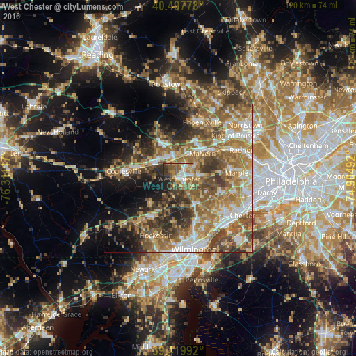
Analysis of West Chester night lights 2016
Square area 10x10 km:
 9.18%
9.18%90-99
8.16%80-89
5.95%70-79
9.69%60-69
11.56%50-59
20.07%40-49
10.37%30-39
10.37%20-29
9.86%10-19
4.76%0-9
0%Square area 50x50 km:
7.17%90-99
7.29%80-89
7.05%70-79
8.28%60-69
10.78%50-59
11.44%40-49
7.8%30-39
8.17%20-29
7.03%10-19
9.6%0-9
15.4%Clear (daylight) street map image can be seen on geolist.org.
Map coordinates:
40° 29' 52" North, 76° 18' 40.2" West
39° 57' 39.5" North, 75° 36' 28.9" West
39° 25' 11.7" North, 74° 54' 17.7" West
Some cities around West Chester sort by population:
• Coatesville
18.6 km =11.6 mi,  277°
277°
• Downingtown
9.6 km =6 mi,  301°
301°
• Village Green-Green Ridge
19 km =11.8 mi,  124°
124°
• Chester Springs
14.9 km =9.3 mi,  357°
357°
• Lionville
11.2 km =7 mi,  336°
336°
• Kennett Square
15.5 km =9.6 mi,  214°
214°
• Paoli
14.4 km =8.9 mi,  51°
51°
• Media
19.4 km =12.1 mi,  104°
104°
4562144 (p: 19,842)
Sources (retrieved 2019-11-25):
» Earth at Night: Flat Maps 2012, 2016