Sanatoga night lights from space
Night Light of Sanatoga (Pennsylvania) from space (United States) Src. Average luminocity for 10x10km area is 53.1201% and for 50x50km: 34.7599%.
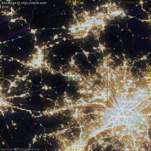
Analysis of Sanatoga night lights 2016
Square area 10x10 km:
 4.38%
4.38%90-99
5.68%80-89
10.39%70-79
5.84%60-69
13.31%50-59
8.44%40-49
15.26%30-39
16.23%20-29
15.26%10-19
5.19%0-9
0%Square area 50x50 km:
3.78%90-99
4.02%80-89
4.88%70-79
5.75%60-69
6.72%50-59
7.87%40-49
5.99%30-39
6.57%20-29
7.69%10-19
13.9%0-9
32.86%Clear (daylight) street map image can be seen on geolist.org.
Map coordinates:
40° 46' 46.8" North, 76° 17' 53.9" West
40° 14' 42.4" North, 75° 35' 42.6" West
39° 42' 22.6" North, 74° 53' 31.4" West
Some cities around Sanatoga sort by population:
• Pottstown
4.6 km =2.9 mi,  270°
270°
• Limerick
6.4 km =4 mi,  104°
104°
• Phoenixville
14.5 km =9 mi,  151°
151°
• Harleysville
18.1 km =11.2 mi,  77°
77°
• Audubon
19 km =11.8 mi,  133°
133°
• Chester Springs
16.8 km =10.4 mi,  186°
186°
• Collegeville
13.9 km =8.6 mi,  118°
118°
• Birdsboro
17.9 km =11.1 mi,  276°
276°
5210764 (p: 8,378)
Sources (retrieved 2019-11-25):
» Earth at Night: Flat Maps 2012, 2016