Cambridge night lights from space
Night Light of Cambridge (Ohio) from space (United States) Src. Average luminocity for 10x10km area is 32.8701% and for 50x50km: 3.4924%.
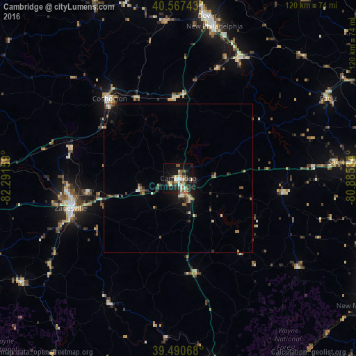
Analysis of Cambridge night lights 2016
Square area 10x10 km:
 3.41%
3.41%90-99
7.79%80-89
2.6%70-79
3.73%60-69
4.06%50-59
6.82%40-49
4.22%30-39
2.44%20-29
10.23%10-19
29.71%0-9
25%Square area 50x50 km:
0.23%90-99
0.6%80-89
0.25%70-79
0.37%60-69
0.45%50-59
0.71%40-49
0.46%30-39
0.42%20-29
1%10-19
2.69%0-9
92.82%Clear (daylight) street map image can be seen on geolist.org.
Map coordinates:
40° 34' 2.7" North, 82° 17' 29.7" West
40° 1' 52.2" North, 81° 35' 18.5" West
39° 29' 26.4" North, 80° 53' 7.2" West
Some cities around Cambridge sort by population:
• Newark
69.3 km =43.1 mi,  272°
272°
• Zanesville
37.6 km =23.4 mi,  254°
254°
• New Philadelphia
52.4 km =32.6 mi,  13°
13°
• Marietta
69.4 km =43.1 mi,  170°
170°
• Dover
55.3 km =34.4 mi, 10°
• Coshocton
35.3 km =21.9 mi,  319°
319°
• Uhrichsville
45.2 km =28.1 mi,  27°
27°
• Saint Clairsville
58.8 km =36.5 mi,  84°
84°
5149007 (p: 10,402)
Sources (retrieved 2019-11-25):
» Earth at Night: Flat Maps 2012, 2016