Dover night lights from space
Night Light of Dover (Ohio) from space (United States) Src. Average luminocity for 10x10km area is 45.619% and for 50x50km: 8.3708%.
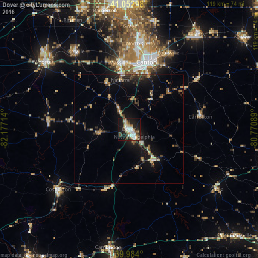
Analysis of Dover night lights 2016
Square area 10x10 km:
 11.9%
11.9%90-99
10.71%80-89
3.91%70-79
4.42%60-69
3.4%50-59
5.95%40-49
2.72%30-39
5.1%20-29
15.31%10-19
31.63%0-9
4.93%Square area 50x50 km:
0.6%90-99
1.03%80-89
0.79%70-79
0.87%60-69
1.16%50-59
0.97%40-49
1.36%30-39
1.64%20-29
2.79%10-19
7.22%0-9
81.57%Clear (daylight) street map image can be seen on geolist.org.
Map coordinates:
41° 3' 10.7" North, 82° 10' 37.7" West
40° 31' 14.2" North, 81° 28' 26.4" West
39° 59' 2.4" North, 80° 46' 15.2" West
Some cities around Dover sort by population:
• Canton
32 km =19.9 mi,  14°
14°
• Massillon
31 km =19.3 mi,  352°
352°
• New Philadelphia
4.2 km =2.6 mi,  145°
145°
• North Canton
40 km =24.9 mi, 8°
• Louisville
39.6 km =24.6 mi,  27°
27°
• Perry Heights
30.5 km =19 mi,  0°
0°
• Canal Fulton
42.3 km =26.3 mi, 345°
• Uhrichsville
17.8 km =11.1 mi,  142°
142°
5152243 (p: 12,899)
Sources (retrieved 2019-11-25):
» Earth at Night: Flat Maps 2012, 2016