Uhrichsville night lights from space
Night Light of Uhrichsville (Ohio) from space (United States) Src. Average luminocity for 10x10km area is 23.1241% and for 50x50km: 6.1249%.
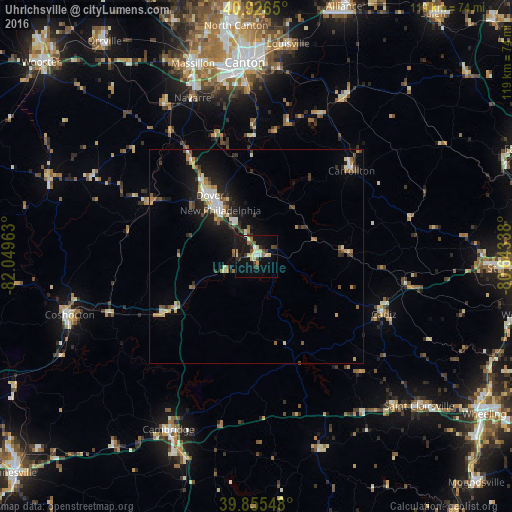
Analysis of Uhrichsville night lights 2016
Square area 10x10 km:
 1.19%
1.19%90-99
4.93%80-89
4.42%70-79
2.04%60-69
1.36%50-59
2.38%40-49
3.06%30-39
4.42%20-29
3.06%10-19
30.44%0-9
42.69%Square area 50x50 km:
0.67%90-99
1.01%80-89
0.65%70-79
0.69%60-69
0.64%50-59
0.9%40-49
0.74%30-39
0.86%20-29
1.51%10-19
5.09%0-9
87.24%Clear (daylight) street map image can be seen on geolist.org.
Map coordinates:
40° 55' 35.4" North, 82° 2' 58.7" West
40° 23' 35.2" North, 81° 20' 47.4" West
39° 51' 19.7" North, 80° 38' 36.2" West
Some cities around Uhrichsville sort by population:
• Canton
45.2 km =28.1 mi,  356°
356°
• Massillon
47.2 km =29.3 mi,  341°
341°
• New Philadelphia
13.6 km =8.5 mi,  322°
322°
• Dover
17.8 km =11.1 mi, 322°
• Coshocton
45.5 km =28.3 mi,  252°
252°
• Cambridge
45.2 km =28.1 mi,  207°
207°
• Louisville
49.9 km =31 mi,  8°
8°
• Perry Heights
46 km =28.6 mi,  346°
346°
5174585 (p: 5,404)
Sources (retrieved 2019-11-25):
» Earth at Night: Flat Maps 2012, 2016