New Philadelphia night lights from space
Night Light of New Philadelphia (Ohio) from space (United States) Src. Average luminocity for 10x10km area is 44.3827% and for 50x50km: 7.5877%.
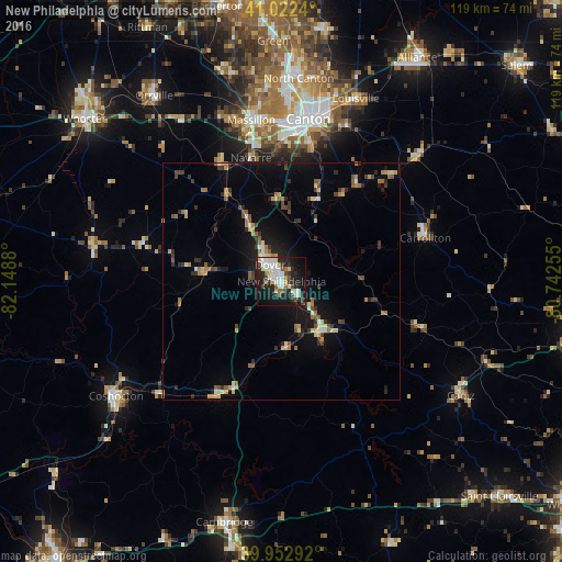
Analysis of New Philadelphia night lights 2016
Square area 10x10 km:
 11.56%
90-99
11.9%80-89
2.55%70-79
3.23%60-69
2.72%50-59
5.27%40-49
3.74%30-39
4.93%20-29
16.84%10-19
30.27%0-9
6.97%Square area 50x50 km:
0.63%90-99
1.01%80-89
0.83%70-79
0.87%60-69
0.97%50-59
1%40-49
1.03%30-39
1.23%20-29
2%10-19
5.88%0-9
84.55%Clear (daylight) street map image can be seen on geolist.org.
Map coordinates:
41° 1' 20.6" North, 82° 8' 55.7" West
40° 29' 23.2" North, 81° 26' 44.4" West
39° 57' 10.5" North, 80° 44' 33.2" West
Some cities around New Philadelphia sort by population:
• Canton
34.8 km =21.6 mi,  9°
9°
• Massillon
34.7 km =21.6 mi,  349°
349°
• North Canton
43.1 km =26.8 mi,  4°
4°
• Dover
4.2 km =2.6 mi,  325°
325°
• Coshocton
42.6 km =26.5 mi,  235°
235°
• Louisville
41.7 km =25.9 mi,  22°
22°
• Perry Heights
34.1 km =21.2 mi,  356°
356°
• Uhrichsville
13.6 km =8.5 mi,  142°
142°
5164390 (p: 17,484)
Sources (retrieved 2019-11-25):
» Earth at Night: Flat Maps 2012, 2016