Branford night lights from space
Night Light of Branford (Connecticut) from space (United States) Src. Average luminocity for 10x10km area is 47.4448% and for 50x50km: 21.6867%.
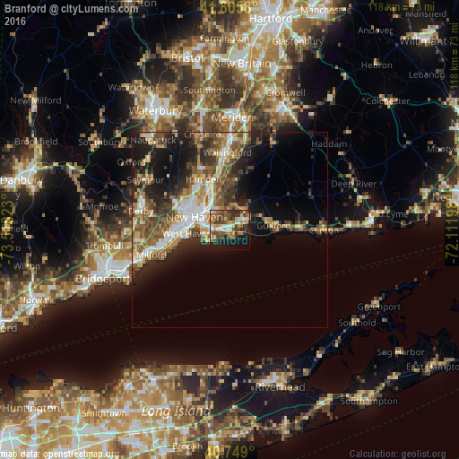

Analysis of Branford night lights 2016
Square area 10x10 km:
 4.55%
4.55%90-99
7.14%80-89
6.01%70-79
6.82%60-69
10.55%50-59
8.44%40-49
13.8%30-39
8.44%20-29
10.55%10-19
18.02%0-9
5.68%Square area 50x50 km:
2.73%90-99
3.33%80-89
2.8%70-79
2.75%60-69
3.38%50-59
4.49%40-49
4.26%30-39
3.58%20-29
6.02%10-19
9.93%0-9
56.73%Clear (daylight) street map image can be seen on geolist.org.
Map coordinates:
41° 48' 20.9" North, 73° 31' 5.6" West
41° 16' 46.3" North, 72° 48' 54.4" West
40° 44' 56.4" North, 72° 6' 43.1" West
Some cities around Branford sort by population:
• New Haven
10 km =6.2 mi,  288°
288°
• Hamden
14.6 km =9.1 mi,  332°
332°
• West Haven
11.1 km =6.9 mi,  264°
264°
• East Haven
4.5 km =2.8 mi,  265°
265°
• North Haven
12.9 km =8 mi,  343°
343°
• Guilford
11.2 km =7 mi,  84°
84°
• North Branford
6.7 km =4.2 mi,  36°
36°
• Orange
17.6 km =10.9 mi, 269°
5283054 (p: 29,438)
Sources (retrieved 2019-11-25):
» Earth at Night: Flat Maps 2012, 2016