North Branford night lights from space
Night Light of North Branford (Connecticut) from space (United States) Src. Average luminocity for 10x10km area is 33.6037% and for 50x50km: 24.4303%.
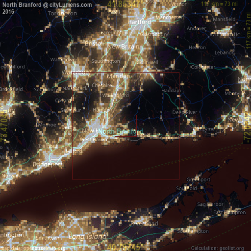
Analysis of North Branford night lights 2016
Square area 10x10 km:
 1.87%
1.87%90-99
3.06%80-89
3.91%70-79
7.14%60-69
5.1%50-59
3.57%40-49
7.31%30-39
12.24%20-29
13.1%10-19
23.47%0-9
19.22%Square area 50x50 km:
3.14%90-99
3.64%80-89
2.8%70-79
3.27%60-69
4.21%50-59
4.93%40-49
5.38%30-39
4.38%20-29
6.19%10-19
9.44%0-9
52.62%Clear (daylight) street map image can be seen on geolist.org.
Map coordinates:
41° 51' 12.5" North, 73° 28' 13.6" West
41° 19' 39.4" North, 72° 46' 2.4" West
40° 47' 50.8" North, 72° 3' 51.1" West
Some cities around North Branford sort by population:
• New Haven
13.6 km =8.5 mi,  260°
260°
• Hamden
13.2 km =8.2 mi,  305°
305°
• Branford
6.7 km =4.2 mi,  216°
216°
• East Haven
10.2 km =6.3 mi,  235°
235°
• Guilford
8.3 km =5.2 mi,  120°
120°
• Madison
15.1 km =9.4 mi,  110°
110°
• Wallingford Center
14.3 km =8.9 mi,  342°
342°
• Branford Center
6.9 km =4.3 mi, 215°
4839636 (p: 14,454)
Sources (retrieved 2019-11-25):
» Earth at Night: Flat Maps 2012, 2016