Orange night lights from space
Night Light of Orange (Connecticut) from space (United States) Src. Average luminocity for 10x10km area is 64.711% and for 50x50km: 29.7431%.
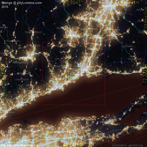
Analysis of Orange night lights 2016
Square area 10x10 km:
 10.23%
90-99
10.06%80-89
7.79%70-79
6.98%60-69
14.12%50-59
22.56%40-49
17.53%30-39
9.42%20-29
1.3%10-19
0%0-9
0%Square area 50x50 km:
4.04%90-99
4.56%80-89
3.56%70-79
3.7%60-69
5.09%50-59
5.86%40-49
5.56%30-39
5.14%20-29
8.32%10-19
13.75%0-9
40.43%Clear (daylight) street map image can be seen on geolist.org.
Map coordinates:
41° 48' 16.9" North, 73° 43' 43.6" West
41° 16' 42.3" North, 73° 1' 32.4" West
40° 44' 52.4" North, 72° 19' 21.1" West
Some cities around Orange sort by population:
• New Haven
8.8 km =5.5 mi,  67°
67°
• West Haven
6.6 km =4.1 mi,  97°
97°
• Milford
6.8 km =4.2 mi,  202°
202°
• City of Milford (balance)
6.8 km =4.2 mi,  206°
206°
• Shelton
7.1 km =4.4 mi,  306°
306°
• Ansonia
8.8 km =5.5 mi,  329°
329°
• Derby
7.1 km =4.4 mi, 311°
• Woodbridge
8.4 km =5.2 mi,  9°
9°
4840104 (p: 13,956)
Sources (retrieved 2019-11-25):
» Earth at Night: Flat Maps 2012, 2016