Atchison night lights from space
Night Light of Atchison (Kansas) from space (United States) Src. Average luminocity for 10x10km area is 16.3377% and for 50x50km: 4.2097%.
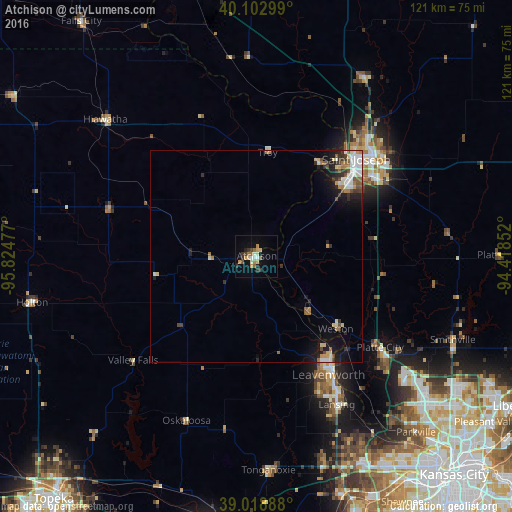
Analysis of Atchison night lights 2016
Square area 10x10 km:
 1.14%
1.14%90-99
1.95%80-89
2.76%70-79
3.25%60-69
3.08%50-59
0.81%40-49
1.3%30-39
4.06%20-29
1.62%10-19
4.55%0-9
75.49%Square area 50x50 km:
0.62%90-99
0.75%80-89
0.56%70-79
0.4%60-69
0.6%50-59
0.44%40-49
0.47%30-39
0.77%20-29
0.84%10-19
2.48%0-9
92.07%Clear (daylight) street map image can be seen on geolist.org.
Map coordinates:
40° 6' 10.8" North, 95° 49' 29.2" West
39° 33' 47" North, 95° 7' 17.9" West
39° 1' 8" North, 94° 25' 6.7" West
Some cities around Atchison sort by population:
• Saint Joseph
32.8 km =20.4 mi,  45°
45°
• Leavenworth
32.8 km =20.4 mi,  148°
148°
• Lansing
39.8 km =24.7 mi, 151°
• Smithville
50.4 km =31.3 mi,  112°
112°
• Parkville
55.7 km =34.6 mi,  137°
137°
• Basehor
49.4 km =30.7 mi,  161°
161°
• Tonganoxie
50.5 km =31.4 mi,  176°
176°
• Savannah
48.9 km =30.4 mi,  30°
30°
4267733 (p: 10,712)
Sources (retrieved 2019-11-25):
» Earth at Night: Flat Maps 2012, 2016