Abilene night lights from space
Night Light of Abilene (Kansas) from space (United States) Src. Average luminocity for 10x10km area is 14.9201% and for 50x50km: 1.0376%.
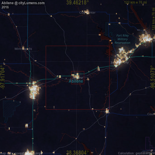
Analysis of Abilene night lights 2016
Square area 10x10 km:
 0.68%
0.68%90-99
0.68%80-89
2.72%70-79
4.59%60-69
3.74%50-59
1.19%40-49
1.36%30-39
2.04%20-29
0.68%10-19
2.72%0-9
79.59%Square area 50x50 km:
0.03%90-99
0.05%80-89
0.23%70-79
0.22%60-69
0.23%50-59
0.15%40-49
0.06%30-39
0.22%20-29
0.16%10-19
0.15%0-9
98.51%Clear (daylight) street map image can be seen on geolist.org.
Map coordinates:
39° 27' 43.8" North, 97° 55' 1.3" West
38° 55' 2" North, 97° 12' 50.1" West
38° 22' 4.9" North, 96° 30' 38.8" West
Some cities around Abilene sort by population:
• Manhattan
62.9 km =39.1 mi,  61°
61°
• Salina
35.5 km =22.1 mi,  256°
256°
• Emporia
106.3 km =66.1 mi,  122°
122°
• Junction City
35.3 km =21.9 mi,  69°
69°
• Newton
97.5 km =60.6 mi,  186°
186°
• McPherson
72.2 km =44.9 mi,  212°
212°
• Fort Riley North
40.7 km =25.3 mi, 58°
• Concordia
82.3 km =51.1 mi,  332°
332°
4267354 (p: 6,558)
Sources (retrieved 2019-11-25):
» Earth at Night: Flat Maps 2012, 2016