Havsa night lights from space
Night Light of Havsa (Edirne) from space (Turkey) Src. Average luminocity for 10x10km area is 10.3571% and for 50x50km: 6.7942%.
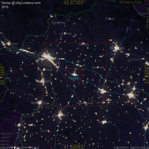
Analysis of Havsa night lights 2016
Square area 10x10 km:
 1.19%
1.19%90-99
2.21%80-89
0.51%70-79
1.53%60-69
0.34%50-59
1.7%40-49
1.02%30-39
0.34%20-29
2.55%10-19
1.19%0-9
87.41%Square area 50x50 km:
0.62%90-99
1.35%80-89
0.52%70-79
0.75%60-69
0.69%50-59
1.13%40-49
0.86%30-39
0.87%20-29
1.76%10-19
4.31%0-9
87.14%Clear (daylight) street map image can be seen on geolist.org.
Map coordinates:
42° 4' 23" North, 26° 7' 8.2" East
41° 32' 56.3" North, 26° 49' 19.5" East
41° 1' 14.3" North, 27° 31' 30.7" East
Some cities around Havsa sort by population:
• Edirne
26.3 km =16.3 mi,  302°
302°
• Lüleburgaz
47.6 km =29.6 mi,  109°
109°
• Kırklareli
39.4 km =24.5 mi,  58°
58°
• Uzunköprü
33.4 km =20.8 mi,  199°
199°
• Babaeski
26 km =16.2 mi,  119°
119°
• Hayrabolu
44.3 km =27.5 mi,  147°
147°
• Orestiáda, GR
24.9 km =15.5 mi,  258°
258°
• Didymóteicho, GR
35.2 km =21.9 mi,  230°
230°
745719 (p: 7,510)
Sources (retrieved 2019-11-25):
» Earth at Night: Flat Maps 2012, 2016