Didymóteicho night lights from space
Night Light of Didymóteicho (East Macedonia and Thrace) from space (Greece) Src. Average luminocity for 10x10km area is 13.9031% and for 50x50km: 4.418%.
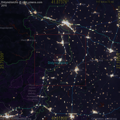
Analysis of Didymóteicho night lights 2016
Square area 10x10 km:
 1.36%
1.36%90-99
2.21%80-89
1.19%70-79
1.19%60-69
2.04%50-59
3.06%40-49
1.87%30-39
1.36%20-29
2.72%10-19
1.36%0-9
81.63%Square area 50x50 km:
0.19%90-99
0.62%80-89
0.47%70-79
0.4%60-69
0.58%50-59
0.9%40-49
0.72%30-39
0.91%20-29
0.85%10-19
1.69%0-9
92.68%Clear (daylight) street map image can be seen on geolist.org.
Map coordinates:
41° 52' 25.5" North, 25° 47' 34.8" East
41° 20' 53" North, 26° 29' 46" East
40° 49' 5.1" North, 27° 11' 57.3" East
Some cities around Didymóteicho sort by population:
• Edirne, TR
36.9 km =22.9 mi,  7°
7°
• Uzunköprü, TR
18.5 km =11.5 mi,  119°
119°
• Babaeski, TR
50.7 km =31.5 mi,  79°
79°
• Hayrabolu, TR
53.2 km =33.1 mi,  106°
106°
• Svilengrad, BG
52.7 km =32.7 mi,  332°
332°
• Orestiáda
17.5 km =10.9 mi, 9°
• İpsala, TR
48.4 km =30.1 mi,  191°
191°
• Havsa, TR
35.2 km =21.9 mi,  50°
50°
736447 (p: 8,336)
Sources (retrieved 2019-11-25):
» Earth at Night: Flat Maps 2012, 2016