Orestiáda night lights from space
Night Light of Orestiáda (East Macedonia and Thrace) from space (Greece) Src. Average luminocity for 10x10km area is 19.1718% and for 50x50km: 7.0682%.
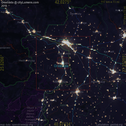
Analysis of Orestiáda night lights 2016
Square area 10x10 km:
 1.7%
1.7%90-99
4.76%80-89
2.04%70-79
1.36%60-69
1.7%50-59
2.21%40-49
2.21%30-39
2.38%20-29
1.7%10-19
17.69%0-9
62.24%Square area 50x50 km:
0.59%90-99
1.45%80-89
0.6%70-79
0.5%60-69
0.76%50-59
1.15%40-49
1.04%30-39
1.01%20-29
1.82%10-19
4.5%0-9
86.59%Clear (daylight) street map image can be seen on geolist.org.
Map coordinates:
42° 1' 39" North, 25° 49' 35.8" East
41° 30' 11" North, 26° 31' 47" East
40° 58' 27.6" North, 27° 13' 58.3" East
Some cities around Orestiáda sort by population:
• Edirne, TR
19.5 km =12.1 mi,  6°
6°
• Uzunköprü, TR
29.5 km =18.3 mi,  153°
153°
• Babaeski, TR
47.6 km =29.6 mi,  99°
99°
• Hayrabolu, TR
58 km =36 mi,  123°
123°
• Svilengrad, BG
40.1 km =24.9 mi,  316°
316°
• Didymóteicho
17.5 km =10.9 mi,  189°
189°
• Lyubimets, BG
52.2 km =32.4 mi,  314°
314°
• Havsa, TR
24.9 km =15.5 mi,  78°
78°
734880 (p: 16,221)
Sources (retrieved 2019-11-25):
» Earth at Night: Flat Maps 2012, 2016