Hayrabolu night lights from space
Night Light of Hayrabolu (Tekirdağ) from space (Turkey) Src. Average luminocity for 10x10km area is 9.7354% and for 50x50km: 4.0062%.
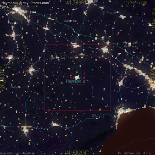
Analysis of Hayrabolu night lights 2016
Square area 10x10 km:
 1.14%
1.14%90-99
3.41%80-89
0.65%70-79
0%60-69
1.46%50-59
1.46%40-49
0.65%30-39
0%20-29
0.65%10-19
0%0-9
90.58%Square area 50x50 km:
0.32%90-99
0.66%80-89
0.26%70-79
0.36%60-69
0.5%50-59
0.62%40-49
0.82%30-39
0.89%20-29
0.75%10-19
2.63%0-9
92.19%Clear (daylight) street map image can be seen on geolist.org.
Map coordinates:
41° 44' 23.7" North, 26° 24' 13.5" East
41° 12' 47.2" North, 27° 6' 24.8" East
40° 40' 55.3" North, 27° 48' 36" East
Some cities around Hayrabolu sort by population:
• Tekirdağ
42.8 km =26.6 mi,  127°
127°
• Lüleburgaz
29.9 km =18.6 mi,  44°
44°
• Uzunköprü
35.5 km =22.1 mi,  279°
279°
• Malkara
39.9 km =24.8 mi,  205°
205°
• Babaeski
24.4 km =15.2 mi,  357°
357°
• Didymóteicho, GR
53.2 km =33.1 mi,  286°
286°
• Havsa
44.3 km =27.5 mi,  327°
327°
• Marmaracık
54.2 km =33.7 mi,  90°
90°
745697 (p: 19,793)
Sources (retrieved 2019-11-25):
» Earth at Night: Flat Maps 2012, 2016