Harqalah night lights from space
Night Light of Harqalah (Sūsah) from space (Tunisia) Src. Average luminocity for 10x10km area is 8.6777% and for 50x50km: 7.1281%.
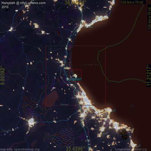
Analysis of Harqalah night lights 2016
Square area 10x10 km:
 0.55%
0.55%90-99
0.55%80-89
1.1%70-79
1.47%60-69
2.75%50-59
0.18%40-49
0%30-39
1.47%20-29
0.73%10-19
0%0-9
91.21%Square area 50x50 km:
1.22%90-99
1.34%80-89
0.57%70-79
0.7%60-69
1.09%50-59
0.79%40-49
0.78%30-39
1.21%20-29
1.72%10-19
3.47%0-9
87.11%Clear (daylight) street map image can be seen on geolist.org.
Map coordinates:
36° 35' 48.6" North, 9° 48' 21.3" East
36° 1' 49" North, 10° 30' 32.5" East
35° 27' 34.6" North, 11° 12' 43.8" East
Some cities around Harqalah sort by population:
• Sousse
25.5 km =15.8 mi,  153°
153°
• Msaken
34.1 km =21.2 mi,  169°
169°
• Skanes
38 km =23.6 mi,  136°
136°
• Hammam Sousse
20.6 km =12.8 mi,  155°
155°
• Akouda
18.6 km =11.6 mi, 164°
• Sahline
35.9 km =22.3 mi, 149°
• Sidi Bou Ali
8.8 km =5.5 mi,  201°
201°
• Port el Kantaoui
17.1 km =10.6 mi, 153°
2470483 (p: 6,942)
Sources (retrieved 2019-11-25):
» Earth at Night: Flat Maps 2012, 2016