Atamyrat night lights from space
Night Light of Atamyrat (Lebap) from space (Turkmenistan) Src. Average luminocity for 10x10km area is 44.9354% and for 50x50km: 6.5866%.

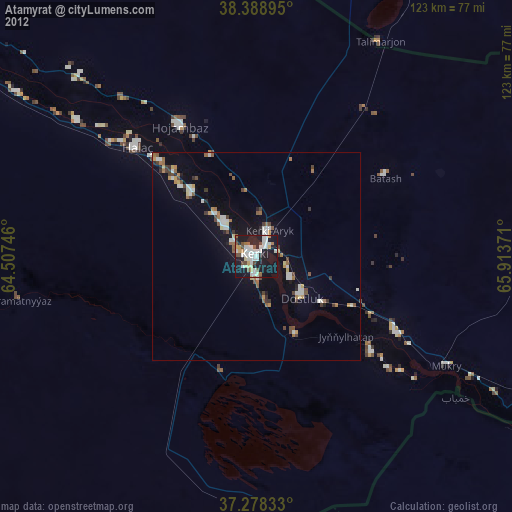
Analysis of Atamyrat night lights 2016
Square area 10x10 km:
 6.46%
6.46%90-99
12.41%80-89
6.12%70-79
2.38%60-69
3.57%50-59
3.91%40-49
5.61%30-39
8.33%20-29
24.15%10-19
26.87%0-9
0.17%Square area 50x50 km:
0.46%90-99
1.31%80-89
1%70-79
0.4%60-69
0.61%50-59
0.66%40-49
1.08%30-39
1.16%20-29
1.44%10-19
6.02%0-9
85.87%Clear (daylight) street map image can be seen on geolist.org.
Map coordinates:
38° 23' 20.2" North, 64° 30' 26.9" East
37° 50' 8.6" North, 65° 12' 38.1" East
37° 16' 42" North, 65° 54' 49.4" East
Some cities around Atamyrat sort by population:
• Qarshi, UZ
124.6 km =77.4 mi,  23°
23°
• Koson, UZ
137.5 km =85.4 mi,  13°
13°
• Gowurdak
73.5 km =45.7 mi,  92°
92°
• Andkhōy, AF
98.5 km =61.2 mi,  184°
184°
• G‘uzor, UZ
125.8 km =78.2 mi,  46°
46°
• Beshkent, UZ
116.2 km =72.2 mi, 19°
• Qarqīn, AF
86.8 km =53.9 mi,  122°
122°
• Nishon Tumani, UZ
103.7 km =64.4 mi, 23°
1219002 (p: 33,242)
Sources (retrieved 2019-11-25):
» Earth at Night: Flat Maps 2012, 2016