Beshkent night lights from space
Night Light of Beshkent (Qashqadaryo) from space (Uzbekistan) Src. Average luminocity for 10x10km area is 22.1463% and for 50x50km: 11.0142%.
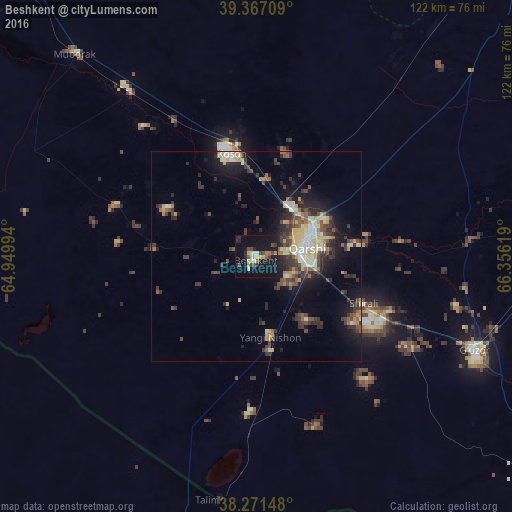
Analysis of Beshkent night lights 2016
Square area 10x10 km:
 1.53%
1.53%90-99
3.23%80-89
3.23%70-79
1.02%60-69
2.04%50-59
2.72%40-49
4.59%30-39
2.89%20-29
4.42%10-19
37.41%0-9
36.9%Square area 50x50 km:
0.75%90-99
1.7%80-89
1.91%70-79
1.07%60-69
0.9%50-59
1.34%40-49
1.97%30-39
3.24%20-29
3.08%10-19
7.46%0-9
76.57%Clear (daylight) street map image can be seen on geolist.org.
Map coordinates:
39° 22' 1.5" North, 64° 56' 59.8" East
38° 49' 17" North, 65° 39' 11" East
38° 16' 17.3" North, 66° 21' 22.3" East
Some cities around Beshkent sort by population:
• Qarshi
12.6 km =7.8 mi,  69°
69°
• Koson
24.7 km =15.3 mi,  346°
346°
• Shahrisabz
105.5 km =65.6 mi,  75°
75°
• Muborak
64.8 km =40.3 mi,  318°
318°
• G‘uzor
56.2 km =34.9 mi,  113°
113°
• Chiroqchi
82.9 km =51.5 mi, 73°
• Nishon Tumani
14.3 km =8.9 mi,  172°
172°
• Qorovulbozor
105.8 km =65.7 mi, 315°
1217703 (p: 17,010)
Sources (retrieved 2019-11-25):
» Earth at Night: Flat Maps 2012, 2016