Wad Rāwah night lights from space
Night Light of Wad Rāwah (Al Jazīrah) from space (Sudan) Src. Average luminocity for 10x10km area is 2.6818% and for 50x50km: 0.545%.
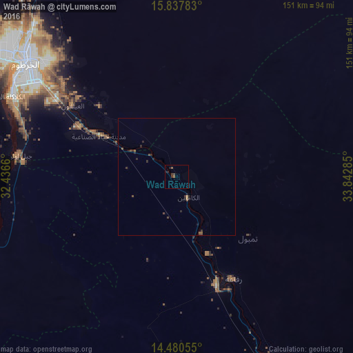
Analysis of Wad Rāwah night lights 2016
Square area 10x10 km:
 0%
0%90-99
0%80-89
0%70-79
0%60-69
0.41%50-59
1.24%40-49
1.24%30-39
1.24%20-29
1.03%10-19
1.45%0-9
93.39%Square area 50x50 km:
0%90-99
0%80-89
0%70-79
0.07%60-69
0.02%50-59
0.21%40-49
0.25%30-39
0.27%20-29
0.29%10-19
0.18%0-9
98.71%Clear (daylight) street map image can be seen on geolist.org.
Map coordinates:
15° 50' 16.2" North, 32° 26' 11.8" East
15° 9' 37" North, 33° 8' 23" East
14° 28' 50" North, 33° 50' 34.3" East
Some cities around Wad Rāwah sort by population:
• Khartoum
78.3 km =48.7 mi,  303°
303°
• Omdurman
89.1 km =55.4 mi,  307°
307°
• Wad Medani
93.8 km =58.3 mi,  154°
154°
• Al Hasaheisa
48.4 km =30.1 mi,  159°
159°
• Al Qiţena
89.3 km =55.5 mi,  248°
248°
• Al Hilāliyya
26.5 km =16.5 mi, 157°
• Al Kiremit al ‘Arakiyyīn
92.8 km =57.7 mi,  193°
193°
• Al Masallamiyya
68.5 km =42.6 mi, 161°
364071 (p: 10,348)
Sources (retrieved 2019-11-25):
» Earth at Night: Flat Maps 2012, 2016